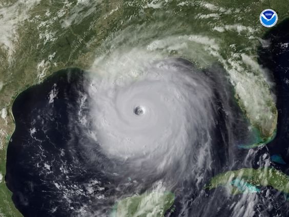
Just a quick report before I shut down my computer and evacuate – probably not to come back on-line for several days at least. It is August 28, 2005 in Gautier, Mississippi, just west of the Mississippi / Alabama state line. Hurricane Katrina is presently expected to make landfall just west of new Orleans, about 100 miles to my west, early tomorrow morning. My wife and I, after much discussion, have decided to stay with friends a mile south of here. The counties to my west, Harrison, on the Louisiana state line, are a mandatory evacuation area. Hancock county to the east of Harrison is recommended evacuation for higher areas, mandatory for low-lying (“A” and “B”). My county, Jackson, is recommended evacuation for higher areas and mandatory for “A” and “B” flood zones.
This is the first of a multi-part series documenting my personal experiences with what has since been called “The Greatest Natural Disaster to Hit the US.”
The local FEMA director is on WLOX (local Radio/TV stations) as I write this, advising people to avoid all areas south of I-10, which is about most of the region we refer to as “The Coast.” He’s saying to bring at least three days of food for folks going to a red cross shelter.
The expected landfall area is 80 Miles +/- either side of Grand Isle Louisiana, which puts my area in the potential danger zone.
I’m not in a flood zone, but am close enough to water that I want to get to higher ground. Winds in this area are predicted to be about 125 MPH – as of now. I’m hearing that gusts from Katrina have already been recorded as high as 200+MPH, but 190 MPH is a given.
The air has that eerie “calm before the storm” feeling I’ve learned to recognize before a bad hurricane. My neighborhood is already looking like a ghost town.
The highway’s here are a mess. Hwy 49 is all north all the way to Hattiesburg. No one can even cross over unless it’s on an overpass.
I-10 is all traffic east, all the way past Mobile. Reports are that the tunnel under Mobile bay is like a parking lot.
Hwy 90 is also backing up now with people using it as an alternate to I-10.
Officials are now publicly saying this will be the worst hurricane since Camille. And now that the coast is so much more built up, the potential damage will be much more extensive. There really is no comparison even to Camille, due to so many more people living here since then.
EVERYTHING here is already planned to be closed tomorrow and Tuesday at least. I knew it would be bad this morning when I woke up and saw churches were cancelling services. Really.
I want to wish everyone who is affected by this monster to be safe, and come through in one piece. I’ll post about my hurricane experiences once power and Internet service is restored.
As hard as this is to say, if you are alive you can always rebuild.
Editors Note: The original version of this diary was posted on the Daily Kos Website titled Hurricane Katrina Report from the Front Lines…. This story was posted the day prior to Hurricane Katrina, when the hurricane was in the news and readers were presumed to have background knowledge. This version is revised to incorporate background info a reader would not have months or years from now.
Related Posts
The Year of Hurricane Katrina : Living through Hurricane Katrina and the year after.
Katrina Aftermath – PTSD and Welfare Queens : A rant during post-Katrina life.
A Bittersweet Homecoming : Returning to Gautier, Mississippi for a short visit.

[…] over here?” to be in the same league as “Hey Bubba, watch this!” As posted in my last diary, my wife and I decided to stay in Gautier, but with friends living on higher ground one mile south […]